On a recent fall Saturday I had the opportunity to float fish the Maury River with my 20-year-old son, now a junior at Virginia Tech. His mother and I are truly thankful he still enjoys our adventures. I think he sees them as a bit of a break from the day-to-day pace that will soon leave him at the doorstep of manhood with career choices, housing decisions and everything else we experienced in our mid-20s.
Our day was the kind you really don’t want to end with a brisk morning that turned warm, a crystal-clear river, peak leaves and scant wind. The fishing; well, it was phenomenal.
The Maury is a smallish river by most standards, flowing some 40+ miles from its source in the mountains above Lexington, Virginia down to its confluence with the James River at Glasgow.
Traveling interstate 81, you might be able to get a quick look at the flow just north of Lexington as it passes beneath the high bridge. If you’re traveling U. S. 11 instead of the interstate, you get a better look at the river. But neither perspective gives you a true picture of this waterway that offers so much to so many including anglers, hunters, paddlers, hikers, bikers and more.
Nor would the traveler who looks upstream or down know that the river is formed miles to the north beyond U. S. Highway 250 where mountain streams snake through the rugged mountains between the western Virginia towns of Churchville and Monterey, many of which hold native brook trout, join to form the Calfpasture River which then merges with the Little Calfpasture River just west of Goshen Pass. It is here that the Maury River is born.
The water of the two major tributaries barely have time to mingle before the Maury enters the famous Goshen Pass and begins a turbulent run downstream, dropping as much as 20 feet in one 100-yard stretch of the river. Once through the pass the river drops into the valley, continuing toward Lexington at a fast pace. It maintains that rate of flow, except where man intervened, until it enters the James River at Glasgow.
While there is challenging whitewater such as Devil’s Kitchen and other rapids too difficult for the novice to tackle up in Goshen, the river offers plenty of Class I and II water that the average canoeist or kayaker can handle. In addition to the fast water at Goshen Pass, there are the remains of Goose Neck Dam downstream from Buena Vista that require care. This is Class II+ water.
According to the DWR the Maury River was first called the North River of the James. It enters the James River from the north. But then came Matthew Fontaine Maury, a professor at Virginia Military Institute in the years following the Civil War during which he had served in the Confederate forces. In those postwar years he fell in love with Goshen Pass and requested that at his death his remains be carried through the pass and on to Richmond for burial. An honor guard of Virginia Military Institute cadets carried out his wish. A monument in his honor now rests on the side of Virginia Primary Highway 39 where it passed through Goshen Pass. And the river was named for him.
The Maury River does not enjoy a reputation for its fishing as do other Virginia rivers such as the James, New, Shenandoah, Rapphannock and others, but it does offer good angling opportunities. The fishing might well be broken down into three of kinds; Goshen Pass, the fast water from Goshen Pass to the James River, and the still water behind the impoundments, primarily the 30-foot high dam at Buena Vista.
The rowdy water of Goshen Pass first is considered by DWR as top trout fishing water, Category A. That means that it is stocked once in October, November–December, and January-February. But it is stocked twice monthly in March, April, and May. Like so many Virginia trout waters, the water becomes too low and warm to hold trout through the summer. Trout are not released in June, July, August, and September. The October releases are often contingent upon the quality of the water. If a long dry summer spell extends well into the fall, the October stocking might be delayed.
While the trout fishing is popular, the smallmouth bass (and some largemouth) and sunfish in the Maury hold more appeal for many anglers. You might catch a smallmouth bass anywhere from the headwaters where the Calfpasture and Little Calfpasture join to form the Maury, to the mouth of the river where it enters the James. Anglers frequently catch smallmouth bass while fishing the Goshen Pass waters for trout, but the best fishing begins downstream where the Pass waters become more gentle.
An ideal bass and sunfish trip might begin at the Glen Maury Park launching area in Buena Vista and end at the Department of Wildlife Resources’ Locher Landing near Glasgow. This is a 12-mile run and even a long summer day won’t give you enough time to fish all of it. Just pace yourself and fish only the most productive water.
In addition to the bass and sunfish the Maury holds populations of rock bass, another stream mate of smallmouth bass in the western part of the state. Other angling possibilities include the likes of carp, catfish and suckers.
My recent float began at the Jordan Point Park (excellent parking) and ended at a private take out above the Ben Salem Wayside at Bare Farm Cabin – a great place to rent if you want to do an overnight stay.
At our starting point we noted the river was low (1.56 on the Lexington USGS gauge) and crystal clear. Leaf fall was occurring so many created an interesting surface mosaic and seasonal fishing challenge.
Soon after the put-in just outside of Lexington you will paddle through a canyon-like setting to a right turn with Class 1 rapid. We fish hard below that cataract where boulders as big as college-sized refrigerators offer brown bass fine habitat. Here we caught our first smallmouth bass as well as red eyes, red-breasted sunfish and a frisky sucker.
I was casting a Nikko Baits Hellgramite threaded onto a Fitt 3/16-oz. stand-up jig head. My son fished a Ned rig with a stickbait. All the fish eagerly gobbled up the tough hellgrammite on the end of my Fenwick rod and six-pound test Berkley XL line.
The river was a cool 54 degrees and most of the good fish we caught were in deep, slow stretches. I was surprised when eight minutes into the trip I caught a 17” two-plus pounder – my PB in the 12 years I’ve been fishing the Maury as part of an annual family reunion. Little did I know we had chosen a remarkable day to fish this river.
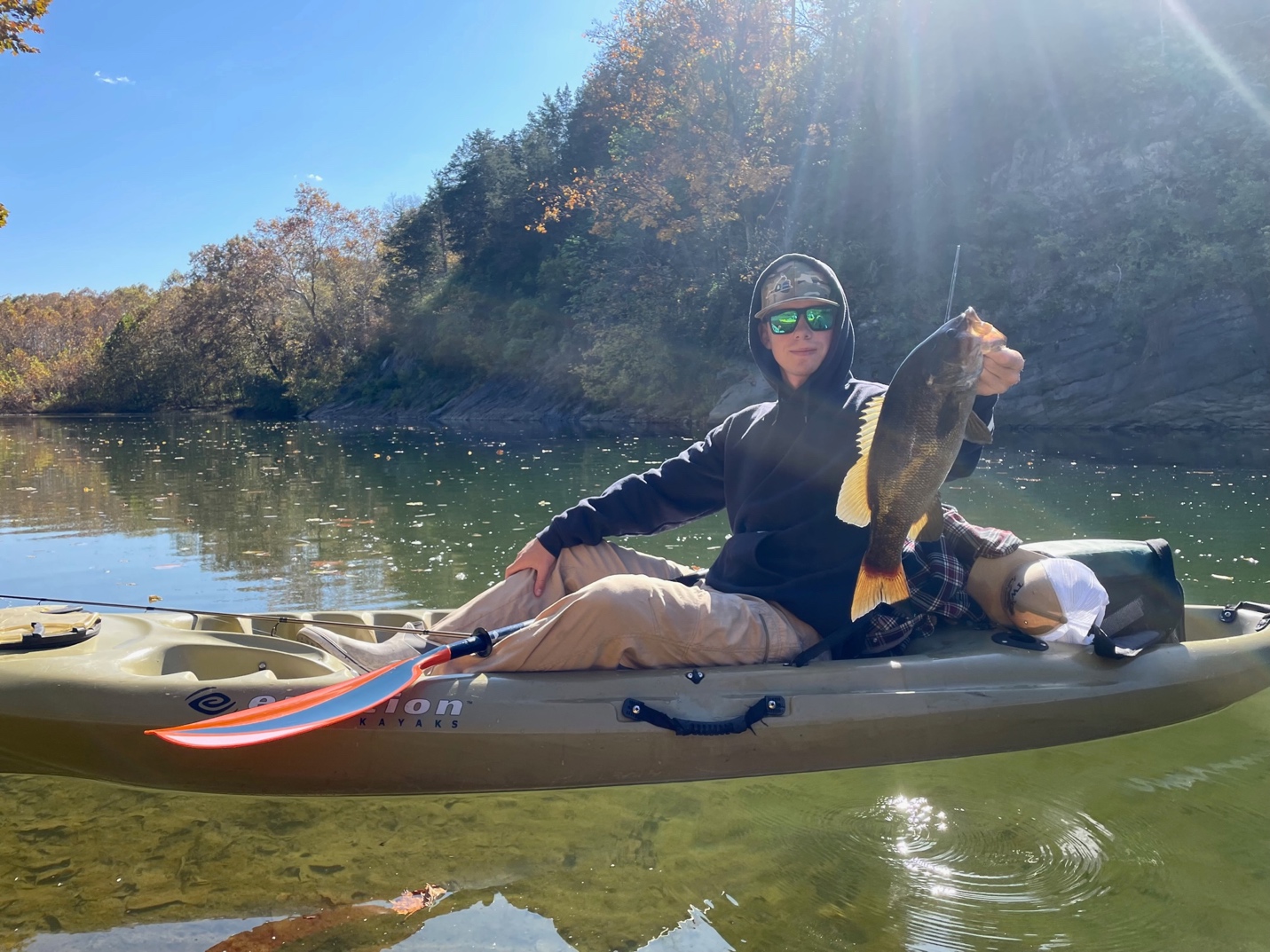
About an hour-and-a-half into the approximately five-mile float I made a cast to the base of a slate gray wall that created the river’s shore. Something grabbed the hellgrammite on the way down and tugged line and then my rod downward. I instinctively set the hook and was into what I thought could be a catfish or carp.
Turns out I had set the hook into a massive Maury River smallmouth – the largest I’ve ever seen. In the clear water it appeared five pounds or better. It took some patient coaxing but I managed to land that beautiful old fish that measured a little over 20 inches. We didn’t have a scale to weigh it. After many pics and some video (we’ll have video on the trip on our YouTube channel), my son slipped the fish back into the river and we watched it purposefully swim back to the deep water from which it came.
Interestingly, we stayed at that hole and caught and released five more smallmouth 16-17 inches as well as a host of smaller ones 12-15 inches. It was an over-wintering haven for the fish in that section of the river – a place to be respected and kept secret. I never knew the river harbored that many big fish.
By the time we reached the remains of Reid’s Lock and Dam we had tallied over 50 fish – mostly smallmouth, with the best five going 13-plus pounds, anchored by that beautiful specimen that touched the magic Virginia citation mark. I caught everyone one of mine on that Nikko hellgrammite – one bait. My son did well using his Ned rig but didn’t have the average size that the hellgrammite produced.
The next milestone on the float was passing under I-81, not far from our take-out. Here the river shallows and it’s more of a water trail than a good fishery until you approach the Old South River Dam, where the water deepens, slows and holds countless fish among boulders and dark holes.
Alas, there would be no more fishing today as our take-out and family reunion celebration awaited at Bare Farm Cabin around a few more bends. A welcome breeze blowing up the river cooled us as the temperature hit 72 by 1 pm. I told my son this was a day to recall whenever things got a little tough for him. I was glad I put a couple Macanudos in my overnight bag because later that evening, as men often do when they are in a festive mood, he and I would regale the adventure with a celebratory cigar.
If you are looking to experience a small Virginia smallmouth river and combine comfortable, private accommodations, give this Destination File a shot.
Maury River Float Trips
Goshen WMA to VDOT Wayside Distance: 2.5 miles — This trip begins at the DWR access at the “swinging” bridge that crosses the river. There is a gravel parking area and gently sloping bank to access the river. CAUTION- This reach of river through the Goshen Pass contains multiple Class II-IV whitewater rapids and should only be navigated by experienced whitewater paddlers. One (100yd) stretch of Class IV rapids is known as the “Devil’s Kitchen”. Take out on river right at the VDOT wayside on Route 39. There is ample parking, picnic tables, a pavilion and portable restrooms at this location.
This float offers beautiful scenery of the Goshen Pass Natural Area Preserve. Much of this section of river is stocked with hatchery trout by DWR, October-May. Bean’s Bottom / Route 631 (Furrs Mill Road) to Jordan Point Park (Lexington) Distance: 2.5 miles — Put in on river left on the upstream side of the bridge. You will have to carry your kayak or canoe down a fairlysteep gravel path to get to the river.
Parking is limited at this site and vehicles should be parked off the shoulder of Route 631 on the east side of the bridge. The one “obstacle” that paddlers should be aware of on this section is the 3 foot high Lexington Water Department Dam located just downstream of the confluence of Whistle Creek.
Take out on river right at Jordan Point Park upstream of the Route 11 Bridge. There is ample parking and restrooms at the park. The park is only open sunrise to sunset. Jordan Point Park to Ben Salem Wayside Distance: 6 miles — This is one of the more popular stretches to paddle on the Maury River. Put in at the north end of the park on river right. There is ample parking and a gentle-sloped bank to launch your boat. Remember the park closes after dark. There are also restrooms located at the entrance to the park. This section of river contains several Class I-II rapids and the remnants of a few old locks and dams leftover from the historic batteau navigation days in the mid 1800’s. At the take out (on river right) you will have to carry your boat up a steep, grassy hill about 100 yards to the road. Ben Salem Wayside to Route 60 DWR Access Distance: 1.5 miles — Put in at the Ben Salem Wayside along Route 60. Park your vehicle in one of two small lots or off the shoulder of Route 60. You will have to carry your boat down a steep, grassy hill about 100 yards to the river. This is a relatively short float, but the last half mile is flatwater created by Moomaw Dam 200 yards downstream of the take out point. Take out is on river left just upstream of the Route 60 Bridge. This is also a trailhead for the Chessie Nature Trail, which runs north from the parking area. Glen Maury Park (Buena Vista) to Miller’s Dam (River Road) Distance: 7 miles — This is a great float with lots of awesome fish habitat. There is ample parking and a grassy bank to launch canoes, kayaks, or rafts just on the upstream side (river right) of the Route 745 Bridge. There is also a handicapped-accessible concrete landing at this site. Paddlers will encounter several Class I-II+ rapids on this reach and the remains of several old dams. These old “broken” dams (Edmondson’s Dam, Goose Neck Dam, Devil’s Step Dam) contain large chunks of concrete and swift currents. Paddlers should scout the areas before running these rapids or “walk” their boats around these hazards. Take out is on river left at the remnants of Miller’s Dam (the take out is immediately upstream of the old lock). This is not an easy place to launch a canoe or kayak as the bank is steep and undeveloped. Parking is adjacent to River Road (SR 663) and limited space can only accommodate 6-8 vehicles. Due to the limited parking at Miller’s Dam, you may want to use this access primarily on weekdays. Miller’s Dam (River Road) to Locher Landing (Glasgow) Distance: 5 miles — This is a very mild and straightforward float. Paddlers will only encounter a few “riffles” and 2-3 Class I rapids in this reach of the lower river. Put in on river left at the remnants of Miller’s Dam (immediately upstream of the old lock). This is not an easy place to launch a canoe or kayak as the bank is steep and undeveloped. Parking is adjacent to River Road (SR 663) and limited space can only accommodate 6-8 vehicles. Take out on river right just downstream of the Route 130 Bridge. There is ample parking and a concrete ramp at Locher Landing. Due to the limited parking at Miller’s Dam, you may want to use this access primarily on weekdays. Glen Maury Park (Buena Vista) to Locher Landing (Glasgow) Distance: 12 miles — This is a long float and could take 6+ hours to complete, depending on the flow of the river. The first half of the trip is where you will find the best fish habitat and paddling challenges. There is ample parking and a grassy bank to launch canoes, kayaks, or rafts just on the upstream side (river right) of the Route 745 Bridge. There is also a handicapped-accessible concrete landing at this site. Paddlers will encounter several Class I-II+ rapids on this reach and the remains of several old dams. These old “broken” dams (Edmondson’s Dam, Goose Neck Dam, Devil’s Step Dam) contain large chunks of concrete and swift currents. Paddlers should scout the areas before running these rapids or “walk” their boats around these hazards. Take out on river right just downstream of the Route 130 Bridge. There is ample parking and a concrete ramp at Locher Landing.